Our 5:45 pickup arrived at 6:20 so I could have had another 30 minutes in bed. Never mind. Again, some of the people I knew from the Cairns trip, and some from Uluru were on this one as we set off on 1500kms of northbound driving to Darwin.
We had two guides this time: Carl and Kiwi. No prizes for guessing where Kiwi’s from. They kindly allowed us to sleep for a while before Carl woke us up to let us know we were about to pass over the Tropic of Capricorn, marked by a big monumenty thing and a line on the road (which is actually in the wrong place now, due to continental drift). We were now officially in the Tropics, though it didn’t feel any different. Yet.
Onwards we went. North. Going north was to become a theme…
Our first rest stop of the day was at Ti Tree, a small (very small) township consisting of an art gallery. And that’s about it. Many townships on the way up the Stuart Highway were formed around telegraph stations and Ti Tree is one of these. Troops stopped here on their treck up to Darwin during WWII as well. Its name has two explanations: it’s either a type of Eucalyptus tree or a specific actual tree, the leaves of which the troops used to flavour their boiled water.
The “Stuart” in Stuart Highway, the road which runs from Adelaide to Darwin, was an explorer who became the first man to travel that entire route around 1860. His name pops up a lot in the history of the Centre. He was also responsible for setting up the telegraph line which ran from Adelaide to Darwin, where it connected with an undersea line to Europe via Java.
North of Ti Tree is Central Mount Stuart. When it was found, it was reckoned as being the central point in Australia, hence the name. It was originally called Central Mount Sturt after an earlier explorer, but for some reason renamed later on. Regardless, it’s 400km or so away from the actual centre anyway.
 Shortly after passing this point, we were invited down to the front to take the microphone and introduce ourselves. The makeup of the bus turned out to be:
1 x Aussie, 1 x Kiwi (guess who), 3 x English, 2 x Danes, 1 x Spanish, 1 x Korean, 1 x Czech, 2 x Japanese, 1 x Bulgarian, 2 x Italians, 1 x Canadian, 2 x Dutch and 1 x German.
The next township was Barrow Creek, another one formed around one of the telegraph repeating stations. We couldn’t stop there, though. A driver had been “abused” because the tourists he kept bringing there were using the toilets! Still, that’s slightly better than the treatment meted out to the original telegraph operators who were speared to death by Aboriginals who didn’t take kindly to people just waltzing onto their land and setting up shop. A Colonel Wiltshire was sent up from South Australia to “protect” the replacement staff. His idea of protection was to kill somewhere between 300 and 1000 of the local population, an act for which he was taken to court but acquitted. Many of the backpacker murders we hear about (including the recent Lees/Falconio one) happened in areas surrounding Barrow Creek. So maybe it’s best that we didn’t stop after all.
North, we travelled. To Wycliffe Well which claims to have 350 types of beer. Along with 40 degree heat and lot of spare time, it may explain why Wycliffe Well also claims to be the UFO capital of Australia. The caravan park displays a sign proclaiming “humans also welcome”, though this doesn’t seem to be the case. Another case of driver-abuse, this time for the overuse of toilet paper, means that the tour no longer stops there. Maybe they need all the loo roll to clear up after the little green men have been at the locals with their anal probes.
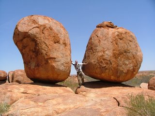
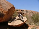
Our first touristy stop was at the Devil’s Marbles. These are huge round rocks, many stacked on top of each other. These were formed as the surrounding Devenport Range was “filled” with magma. As this cooled, it cracked vertically and the inland sea found its way into these cracks. This caused further cooling and horizontal cracks, effectively at that point making thousands of individual rocks. They were flat then, but as the sea disappeared over time and the rocks became exposed, they were weathered and rounded leaving the “marbles” we see today.
 The “Devil” part of the name comes from one of two sources. The Aboriginal version tells of the Devil Devil man who lives in the area – a scare tactic used by parents to stop their children wandering off and eating the many poisonous plants found locally. The “white man” version is also related to the vegetation and the fact that when sheep were released here, they all died from the poisons – hence “Devil’s Land”.
We had lunch here in the baking heat and then boarded the bus to head up to Tennant Creek. This townshop was named after John Tennant, a friend of Stuart’s who provided him with horses for his trek. We saw our first traffic lights for 500km, and amazingly they stayed green. A quick stopoff to get some provisions (OK, sweets) and we drove up to the Mary Ann dam to swim in the murky green water and mess about on a platform anchored a short way out.
As we journeyed (north, for a change), Carl told us of some of the places we passed. Attack Creek was named for an attack (wow) on Stuart’s party by Aboriginals as the explorers were using the local water supply. They suffered so many losses, they had to head back to the nearest town… Adelaide, 2000km south and where they had started from. On the “old” Stuart Highway (a single-laned road now replaced by a 2-lane highway) we saw Churchill’s Head. Well, a rock called Churchill’s Head which looks almost, but not quite, entirely unlike any representation of Churchill you could imagine.
Our stop for the night was to be Banka Banka Station, a working cattle farm with a couple of ‘roos, some calves we could pet (one of them took a real shine to me), and emu and three turkeys who really needed to look at a calendar and consider taking a long holiday.
Will and Helen run the station and after dinner, Will does a slide show telling visitors all about what they do and so forth. This runs for about an hour and I’m pretty certain everyone in the group found it interesting.
Banka Banka is 80,000 acres of land. Including the other two stations which are part of the same business, that’s 11,600 square kilometres for them to rear cattle on. An area larger than Jamaica. The original owner could have walked from Darwin to Adelaide and not left his property. The largest of the stations is 6.8 million hectares in size, which is roughly the size of Holland.
 New “recruits” at the station are called jackaroos or jillaroos, depending on their sex. They get $250 a week, plus food and board. In return, they work seven days a week and very long hours. After three years they may be promoted to ringer or stockman, the equivalent of the American cowboy, which nets than a pay rise of $100 a week.
In the wet season it’s possible for 18 inches of rain to fall in one night and vegetation just shoots up. This grass only contains 2% protein due to its quick growth, so supplemental “lick blocks” have to be distributed to the cattle.
The cattle are herded using horses, planes, helicopters and motorcycles in various combinations. The plane “divebombs” the cattle and has a police siren strapped to it to further convince them to move. Cattle are kept near a watering hole and the motorbike kept on hand in case they bolt.
They are then moved to a holding yard where they are tagged – a different coloured ear tag for different years of birth – and branded if necessary. Males are neutered to prevent inbreeding. Will described this process in detail and a goodly portion of the audience winced at his tales of “prairy oysters” being removed.
Females are pregnancy tested and separated based on the rough due date of their offspring, and calves over 6 months old are weaned. Steers (castrated bulls) over 350kg are separated fromt he herd and loaded onto road trains for the journey to Darwin. These are the ones that will end up on plates with BBQ sauce. 3000 steer are usually transported at one go on roughly 17 road trains, which transfer them to a ship in Darwin. From here, they’re sailed to Indonesia where feeding yards plump them up before they’re slaughtered, butchered and shipped to various destinations.
Will assured everyone that the travelling conditions are as good as can be. After all, uncomfortable and unhealthy transport can mean dead cattle and they’re worth around $2000 a head. If the journey on the road train exceeds 12 hours, the the cattle – by law – have to be let off for a drink and a feed. A nightmare situation as there’s no guarantee of being anywhere near a station where they can be easily reloaded.
The final part of Will’s talk discussed water divining and how it magically works. He demonstrated with two pieces of wire, each about 50cm long with a “handle” bent at one end and a slight downward point at the other. Holding these loosely in the hands, they will cross over (or swing wide – it varies from person to person) when you walk over a water source.
Several people in the group tested this and it worked every time, accurately locating a buried water pipe that ran from the water tank to an outdoor tap. Quite amazing!
With a 6am rise coming up, everyone passed on Will’s offer of further chats and beers and headed for bed; some indoors, some out but all conked out completely within thirty minutes.